7. Change Management#
Contents:
7.1. Overview#
The objective is to update the NVD data on a regular basis as soon as mechanisms have been established between NVD’s partners. One of the mechanisms is establishing change management principles. Two basic concepts are needed: identification rules and definition / classification of change.
Identification Rules defines the identification mechanism used as precisely as possible. In terms of change
management, the NVD doesn’t attempt to track the evolution of phenomena in the real world (features), but rather of the
objects that represent them. In other words, the NVD does not monitor real changes in the territory; they identify only
the effects they have on the data.
Many projects (or the literature) deal with update management and time modelling 1 2 3. The model herein was developed in cooperation with the Centre for Research in Geomatics (CRG) at Laval University 4.
It is aimed to monitor the evolution of objects in order to identify any changes that may have occurred between two observations, whether successive or not. The discrepancies observed between two observations are referred to as the differential 5. Change management also makes it possible to track updates as well as data corrections. The purpose of update management is to facilitate synchronization of databases from producing partners and customers based on current national views (see Figure 1: Evolution of the database in time).
The update management process must also make it possible to reconstitute the data as it was on a previous date.
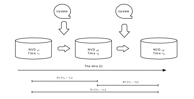
Figure 1: Evolution of the database in time.#
7.2. Object Life Cycle#
NVD data constitutes the best representation of the real-world phenomena of interest, unless proven otherwise. The geometric data in the NVD must undergo a minimum of change. Changes occur when a new information source offers a better representation than the preceding one.
The effects on NVD data will therefore be established based on the preceding representation. Data life cycle is
therefore limited by two events. The cycle always begins with an addition (assignment of a new NID) and ends with
retirement. Between these two events, geometric or descriptive modification or confirmation of the preceding state
can occur, while maintaining the same NID. Data with the effects addition, geometric or descriptive
modification, and confirmation are active (or current) features. Features with the effect retirement are
non-active (historical) data.
7.3. Effect Types#
Updating makes it possible to establish a parallel between existing data and the new data from an update. The latter
has certain effects on the data. The following effects can be classified as:
7.3.1. Addition (Existence)#
When a new object has no geometric counterpart in the NVD, a new object is added, along with a new NID.
7.3.2. Retirement (Existence)#
When an object no longer represents a feature, the object is retired. This type of object is removed from the
current data while maintaining its NID.
7.3.3. Modification (Evolution)#
An object is said to be modified if one of its descriptive attributes or its geometric representation is different.
In this case, the initial NID is preserved for the new version of the object. Two types of modification are possible.
7.3.3.1. Descriptive Modification#
A descriptive modification occurs when a pair of objects from the same class is geometrically identical but has
different attribute values. For example, the type of surface of a specific road may have changed from unpaved to
paved.
7.3.3.2. Geometric Modification#
A geometric modification occurs when a pair of objects from the same class has different geometries that describe the same phenomena.
There are three types of geometric modification currently defined within the NVD. Each has a certain level of complexity. In comparing two representations (old and new), it is possible to define geometric modifications as being:
7.3.3.2.1. First Method#
While comparing two objects, if one vertex is different from its previous representation, the old representation is retired and a new representation added. This method of managing representation modifications means that geometric modifications are not followed.
7.3.3.2.2. Second method#
The second method of managing representation change is based on comparing the old and the new Junction locations. Two Junctions always bound a Network Linear Element. Any modification along an element (geometric representation) may occur between its Junctions. These are treated as a geometric modification while conserving its NID. If, for whatever reason, one of the old Junctions located at one end of the Network Linear Element has changed, then this Network Linear Element is retired and a new one added.
7.3.3.2.3. Third method#
The third method is based on topological links. If the representation of the Linear Element Junctions have maintained the same topological links (even if the Junctions have moved and the Network Linear Element geometry has been modified), then these changes are treated as a geometric modifications and the Network Linear Element and Junctions maintain their NIDs.
7.3.4. Confirmation (Evolution)#
Alongside change, there is confirmation of objects when the geometric or descriptive attributes have not been
modified.
7.4. Used Effects#
7.4.1. Segmented Data#
Feature classes with geometry track change using all effects defined in Types d’effets.
In the segmented model, the effect must be associated to the complete Network Linear Element even if this one is broken
up into several segments because of a change of attribute. I.e. the same effect must be applied to all the segments
that have the same value of attribute NID. The segments that describe the same Network Linear Element can have only one
effect and the set of priorities is as follows: Addition, Descriptive Modification and Confirmation.
The follow-up method for geometric modifications is indicated by the change management provider.
7.5. Example#
The following example is designed to illustrate update management for better comprehension. Figure 2: Example of an
update demonstrates the comparison between the original data and new data. In terms of geometry, a single Road Element
(object 6) was added with respect to the original data. In terms of description, the type of surface of the Road
Element (object 2) has changed from unpaved to paved.
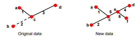
Figure 2: Example of an update.#
Objects |
Explanation |
Effects |
|---|---|---|
3 |
No correspondence with a new object. |
|
4 |
No correspondence with an object in the original data; the arrival of object 6 changed the topological structure of the objects (and therefore the geometry). |
|
5 |
No correspondence with an object in the original data; the arrival of object 6 changed the topological structure of the objects (and therefore the geometry). |
|
6 |
No correspondence with an object in the original data; the feature was not represented. |
|
e |
No correspondence with an object in the original data. |
|
f |
No correspondence with an object in the original data. |
|
2 |
Attribute value changed. |
|
1 |
Geometry and attributes did not change. |
|
a |
Geometry and attributes did not change. |
|
b |
Geometry and attributes did not change. |
|
c |
Geometry and attributes did not change. |
|
d |
Geometry and attributes did not change. |
|
Table 1: Updating effects.
7.6. References#
- 1
Langran, Gail. Time in Geographic Information Systems, Éd. Taylor & Francis, 1993, 187 p.
- 2
Peuquet, Donna J. It’s About Time: A Conceptual Framework for the Representation of Temporal Dynamics in Geographic Information Systems, Annals of the Association of American Geographers, vol. 84, No. 3, 1994, p. 441-461.
- 3
Worboys, Michael F. A Unified Model for Spatial and Temporal Information, The Computer Journal, vol 37, No. 1, p. 26-34.
- 4(1,2)
Pouliot, J., Larrivé, S., and Bédard, Y. Typologie des mises à jour, 2000, 11 p.
- 5
The differential corresponds to the set of differences observed between two landmarks of the territory 4.